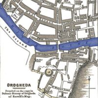
Map of Drogheda
Dublin Core
Title
Map of Drogheda
Date
ca.1657-1749
Creator
F.S. Weller
Description
This image provides an accurate depiction of the layout for the city of Drogheda in the time period that the siege of 1649 took place. This image allows for a visual understanding of where specific actions took place during the battle.
Source
History of the Commonwealth and Protectorate, 1649-1656 (1903) volume 1 page 113
Subject
Art
Rights
Public Domain
Contributor
Kayla Kotke
Still Image Item Type Metadata
Original Format
scan
Physical Dimensions
1,454 × 2,224 pixels
Files
Citation
F.S. Weller, “Map of Drogheda,” History of Ireland, accessed December 23, 2024, https://carmichaeldigitalprojects.org/ireland/items/show/73.

