The Donegal Corridor
Dublin Core
Title
The Donegal Corridor
Date
September 1942
Coverage
1941-1945
Description
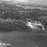
Here is a photograph of the Donegal Corridor taken in September of 1942. The Corridor was located over south Donegal, north Leitrim, and north Sligo, and met the Atlantic. The Donegal Corridor is especially interesting for one reason in particular. Although De Valera had declared that Ireland would maintain a neutral position in the war, they did not completely avoid participation. As the Battle of the Atlantic broke out, it became obvious to Ally forces that planes would be needed for protection to ship convoys against the German U-boats. Ireland allowed the Allies to gain access to the Atlantic through their safe, neutral territory in County Donegal. The path that the Allies were allowed to take came to be known as the Donegal Corridor. Of course, this kind of Irish involvement led to deeper involvement. Eventually, the Irish were so aware of the Ally planes that they could report when one crashed before the British knew about. They often had a hand in sending the Ally troops safely back on their way as well.
Source
McGowan, Joe. 2003. "The Donegal Corridor and the Battle of the Atlantic". History Ireland. 11 (2): 6-7.
Lydon, James F. The Making of Ireland. London: Routledge, 1998.
Keogh, Dermot. Twentieth-Century Ireland. New York, N.Y.: St. Martins, 1994.
Subject
War
Rights
Author: Joe McGowan
Published by Wordwell Ltd in the journal "History Ireland."
Published by Wordwell Ltd in the journal "History Ireland."
Contributor
Kelsie Cagle
Still Image Item Type Metadata
Original Format
photo
Physical Dimensions
unknown
Files
Citation
“The Donegal Corridor,” History of Ireland, accessed December 17, 2024, https://carmichaeldigitalprojects.org/ireland/items/show/42.

